I have always been in awe of the sight of mountain peaks reaching up to the sky, bathed in sunlight. Powerful, monumental, unshakable Atlanteans, breathing calm. And if I am faced with a choice between the sea, the forest and the huge rock masses, I will choose the latter without hesitation. The only things better than mountains are mountains!
And there are few places on the planet where I felt such inspiration as next to the majestic Andes. As part of the Cordillera mountain system that bisects the planet from the northernmost tips of Canada almost to Antarctica, the Andes proudly bear the responsibility of keeping the waters of the Pacific and Atlantic oceans in the southern hemisphere from mixing. The highest, longest, youngest mountains in the world. Rising to a height of almost 7,000 meters, strewn with dormant and waking volcanoes, this huge prehistoric creature stretches over 9,000 kilometers and plunges its southern edge into rough waters, forming a complex pattern of straits and glaciers, where ships perished for many centuries. The Andes keep many secrets, mysteries and dangers: somewhere the Incan gold is hidden, somewhere planes crashed.
This is where I come back every time an airline like Iberia, Lufthansa or Turkish Airways announces a sale.
Northern Andes
In the north, the Andes rise above the tropical rainforests of Venezuela, Colombia and Ecuador; their character is difficult: the height of 4500-6000 meters and changeable weather require special skills from tourists. But you can choose a simpler option: rent a car and drive around the foothills of volcanoes and lakes, or take a ride on the longest cable car in the world (almost 2 kilometers) Teleferico de Merida in Venezuela.
Central Andes
In Peru and Bolivia, the Andes contain in their depths vast and fertile plateaus on which the Incas once built cities. But for me, the main treasures of these places are the high-mountain lakes, deep like Titicaca and turned into salt marshes like. You can spend a stunning few days exploring the customs of the people of Taquile Island on Titicaca, where men knit from colored wool. Or spending the night on the reed-woven islands of Uros under the huge and bright stars at an altitude of 3800 meters. Or sweeping with the breeze across a huge pit of salt. Or coming up with the most incredible compositions for photography in a place where there is no perspective. And, of course, enjoying the most memorable sunsets of your life.
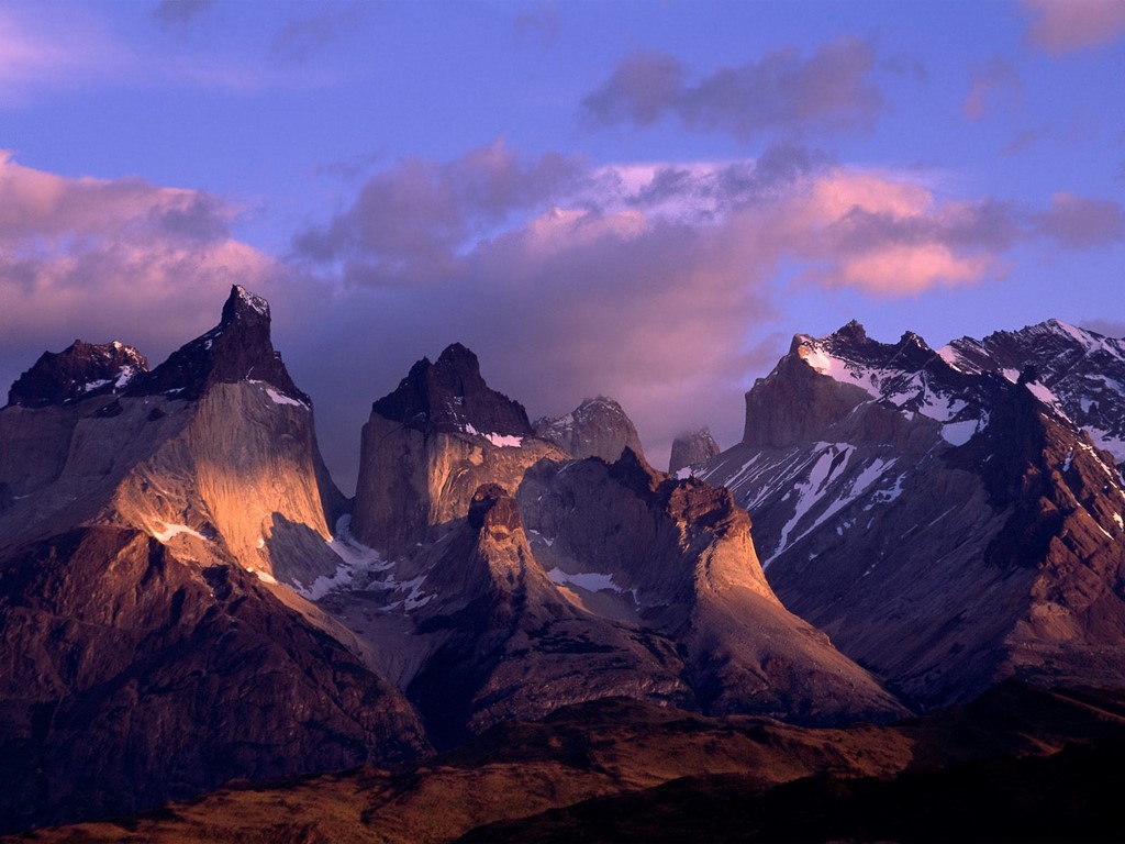
Southern Andes, Carretera Austral
The long and narrow strip of land called Chile and the endless Argentine pampas stretch along the Andean ridges, to the tops of which clouds cling. And they cling in the literal sense: rain clouds driven by Pacific winds cannot overcome the mountain barrier and shed precious moisture on the southern Chilean side (northern Chile, with the world's driest Atacama Desert, is not so lucky). The famous road built in the mid-1970s under Pinochet, the Carretera Austral, or “southern road,” winds here. This is one of the most picturesque and interesting routes I have ever traveled; it provides an opportunity to fully enjoy the beauty of mountain peaks over 1,240 kilometers, wild rivers, azure lakes and proud pine trees.
It is better to travel in the summer months (December to February), since at other times of the year the ferry crossings do not operate and you will not be able to enjoy all the delights of the trip. Therefore, feel free to plan a big vacation for the January holidays and then, in addition to the famous South Road, you will be able to see the huge Perito Moreno glacier, breathe in the famous Patagonian winds and find out why Tierra del Fuego is called so. By the way, the Northern and Central Andes are friendly to travelers all year round.
Where to start
The starting point of Carretera Austral is the Chilean city of Puerto Montt. This is a nice small settlement, imbued with a European spirit, from where tourists, after admiring the ancient Cathedral made of mahogany, go to the Lake District, to the Villarrica volcano or to the island of Chiloe. Here you have to decide how you will conquer the Southern Road: the bravest ones hitchhike or ride bicycles, while the rest rent a car.
From Chiloe Island you can take a ferry to the town of Chaiten and head either north or south.
Another option is to start in the south, from the village of Villa O'Higgins, which can be reached by ferry from Argentina, which runs several times a week from November to March and takes only pedestrians or cyclists on board (costs about $60, or 40,000 pesos) , or entrusting oneself with care travel company. She will not only organize transportation to the ferry by bus, but will also offer to explore the glaciers on the lake “on the way” (the tour will cost from $130).
What to take with you
- Regardless of which method of travel you choose, you need to have a supply of provisions with you; you will find supermarkets only in relatively large settlements; in others populated areas– only village shops with a minimum set of products.
- Don't forget a set of medications and essential supplies you need (from bandages to toothpaste and repellents). Carretera Austral is not a place where you can take just a passport and a credit card.
- Comfortable clothing and shoes are a must as there are so many stunning, inviting places to explore!
- There is enough cash in local currency (Chilean pesos), you won't find ATMs until Coyahique, and cards are not accepted anywhere.
If you choose to travel on foot or by bike
Since the distances between populated areas and campsites are large, you will need:
- tent,
- sleeping bag (in the mountains, even in summer the nights are cold),
- gas-burner,
- pot and dishes,
- and other camping equipment.
You can rent everything you need, including a bicycle, in Puerto Montt (the choice is very limited and the prices are very high) or in Santiago, where there are a huge number of rentals with good bicycles. To do this, you will need to present a passport and a bank card to hold the deposit (depending on the rental period, from $250). Rental prices start from $30 per day or $120 per week.
If you decide to travel by car
You can rent a car in Puerto Montt or, as I did, in Santiago (in this case, you will need to set aside a few days to drive almost 1000 kilometers along the magnificent highway, stopping at wineries and visiting national parks).
- Prepare, in addition to your usual license, an international license (some rental agencies will not issue a car without them) and, of course, a bank card with a sufficient amount in the account to block the deposit.
- Explore the websites of rental companies to choose the best one suitable option. Under no circumstances should you look at small cars, only four-wheel drive! If possible, avoid options for cars that look like they just came out of the showroom; choose a car that has been baptism of fire, because on gravel roads small stones will inevitably fly.
- To the south of Carretera Austral the Andes are filled with many magnificent landscapes, such as the famous Fitzroy Peak and the beauty of the Torres del Paine National Park. But, since some areas of the country are occupied by impassable mountains, part of the journey will have to be done through the territory of Argentina. To do this, you will need special documents for the car. Be sure to contact the rental agency in advance - documents for crossing the border take several days to prepare. And be prepared for the fact that you will be charged a fee of $200 for registration.
- You will rarely see gas stations along the way, so take advantage of every opportunity to replenish your gasoline supplies.
So, you've saddled up a four-wheeled beast (I, for example, got a red pickup truck, on the hood of which someone was playing tic-tac-toe with a nail) and are ready for adventure.
By sea
At the very beginning of the journey, three ferries will be waiting for you, which will circle the inaccessible mountain slopes covered with dense forest by the sea (see map below). The first ferry leaves from La Arena every hour and costs about $15 (10,000 pesos) per car. In half an hour you will reach the peninsula, which can only be reached by sea. The second ferry departs from the village of Ornopien (which has several shops and overnight stops), located at the southern end of the peninsula, twice a day - in the morning and in the afternoon. It is better to check the schedule in Puerto Montt. This ferry takes 5 hours, the ticket costs $54 (35,000 pesos), and this price includes the third ferry, which departs when all passengers on the second ferry have safely covered 10 kilometers of gravel road.
By land
As a result of all the sea voyages, during which majestic mountains, forests and waterfalls will float past, you will find yourself in the village of Caleto Gonzalo. From here, boldly head south, stopping at picturesque places and climbing deep into the mountains. You will travel at an average speed of 50 km/h, so you will not miss signs for recommended hiking trails to particularly beautiful and amazing natural treasures and numerous national parks.
Carretera Austral ends in a dead end in the village of Villa O'Higgins, from where you can cross to Argentina (only those traveling on foot or by bicycle are taken on the ferry), or return back if you are traveling by car.
Where to go
Along the entire Southern Road you will find several opportunities to cross the border with Argentina: near the village of Santa Lucia, near Lago las Torres park, the town of Coyaqui and before reaching Cochrane. I would highly recommend the latter option, as not only will you be able to see almost all of Carretera Austral, but you will also drive past a magnificent lake called Lago General Carrera in the Chilean part and Lago Buenos Aires in the Argentine part.
Tourist infrastructure
You can spend the night in campsites that are scattered throughout Carretera Austral, or in populated areas. Almost all locals rent rooms from $10 to $55 (8,000-35,000 pesos) per night for two and will be happy to feed you breakfast (not always for an additional fee). Free campsites are simply cleared sites. Those equipped with a toilet, hot shower and awnings will cost from $5 to $10 per night.
For example, on January 2, I stopped in the picturesque village of Via Cerro Castillo, where everyone gathered for dinner in the evening big family owners. Despite my limited knowledge of Spanish, I was invited to share a meal with everyone and enjoy a wonderful evening. The men prepared a traditional dish - roasting a young lamb on a cross - a la cruz, and the women cut fresh vegetables and herbs. It was the most delicious lamb I've ever tasted in my life. And the glare of the fire on their open and friendly faces, songs accompanied by an accordion and majestic mountains under the shadow of the starry sky are forever etched in my memory.
Catering establishments are found only in the largest settlements: Ornopirene, Koyaki, Cochrane. In other places, the best you can hope for are small grocery stores. I usually tried to have a hearty breakfast and dinner where I spent the night (if the hosts didn’t cook, I asked permission to use the kitchen), and during the day, pre-prepared sandwiches helped me out.
Southern Andes, Patagonia and Tierra del Fuego
On the western edge of the Patagonian steppes rise the Southern Andes. They are no longer as high as in the north, but no less beautiful. Along the entire foothills of the mountains there are amazing nature reserves, the main pearls of which are the giant Perito Moreno glacier, one of only two on planet Earth that are not decreasing, but growing, and Torres del Paine Park, the harsh beauty of which attracts travelers from all over the world. What wonders Patagonia has in store and how to get to them is well written.
And further south, the red grass of Tierra del Fuego rustles in the wind, where, according to legend, giants lived, and the Andes descend their peak-studded tail into the ocean, from which glaciers slide down like caps. Here, as the last stronghold of the mountains, Cape Horn rises from the water, and landing on it is a matter of luck. Few ships and fierce cold currents travel between this outpost with a lonely lighthouse and Argentina.
The Andes are multifaceted and unpredictable, they fascinate and make you fall in love; once you see them, you will come back again and again. After all, the only thing better than the mountains is the Andes!
The Andes Mountains are a unique mountain system stretching across almost the entire territory South America. The Andes Mountains are the longest mountain system, its length is 9 thousand km. and also one of the highest, but still not the highest, but this is for now, because the mountains still continue to grow. We look at the famous Andes mountains. ( 11 photos)

The Andes Mountains completely, from the north and from the west, circled South America, located along the coast of the Atlantic Ocean. The Andes Mountains are relatively young; the history of their origin dates back to the Jurassic period. The Andes Mountains are one of the largest mountain systems formed during the last major era of the Earth's geological history.

As a result of the collision of three lithospheric plates, the Nazca, Antarctic and South American, the first two sank under the larger South American, even in the history of the formation of mountains we see distinctive feature, usually the origin is the collision of no more than two plates. Surprisingly, seismic activity in the Andean pores continues to be traced to this day, that is, the mountains are actively growing. And their growth is more intense than all other mountain systems, which one way or another are increasing in size.

Thus, in a year the Andes grow by more than 10 cm, who knows, perhaps soon they will become the most high mountains world, but for now the dominant position is occupied by. A height of the Andes mountains is 6962 meters, the peak of the Andes mountains is a peak called Aconcagua. The average width of the mountains is 400 km, the widest point reaches 750 km. The Andes Mountains are conventionally divided into three zones: Northern, Central and Southern Andes.

Among all the other advantages of such impressive mountains, one more thing can be attributed: the Andes mountains are a line of conventional division; they separate water collections. The Andes are also the source of many large rivers and lakes; it is here that the famous river takes its source, which then spreads over hundreds of kilometers. The Andes Mountains have their own small lakes located right between the slopes, which either dry up or refill, depending on the time of year and precipitation. Andes Mountains coordinates 32°39′10″ S w. 70°00′40″ W. d. (G) (O) (I)32°39′10″ S w. 70°00′40″ W. d.

Due to the different climatic conditions in which the Andes are located, the mountains have unequal and dissimilar structures. So in the northern part of the Andes is located a large number of volcanoes, some of them are still considered active, and the Central part is characterized by the sources of many rivers, the Southern part of the Andes is characterized by low peaks and large glacial massifs, spread over almost most of this mountain system, the ice here begins already at an altitude of 1,400 meters.

Due to its impressive size, the Andes are located in 5 climatic zones simultaneously: equatorial, subequatorial, tropical, subtropical and temperate. The Andes also penetrate 7 countries of South America; the Andes are located on the territory of: Venezuela, Colombia, Ecuador, Peru, Bolivia, Chile and Argentina. Moreover, each country is proud of the location of one or another section of mountains on its territory.

Moreover, the Andes Mountains are also a rich reserve of various natural resources; in the Andes there are large deposits of non-ferrous metals: tin, lead, copper, zinc, etc. Active mining of iron and sodium nitrate is also carried out here, but gold deposits are of particular importance , silver, platinum and in some places precious stones(emeralds). The Andes also store oil and gas reserves. In general, the Andes are a real natural treasure trove for.

Today, in times of active tourism, when everyone can visit any corner of the planet if they wish, climbing the Andes is becoming widely popular. In some countries where the Andes are located, there are specialized centers that will prepare and guide you to admire the majestic slopes of the mountains. Of course, you won’t rise to a height of 6 km, but I think you don’t need such an unearthly height. To enjoy all the delights of the picturesque view, 1.5 km will be enough. It cannot be said that the Andes are particularly difficult to climb; some areas can be climbed without special climbing equipment.

Who would have thought that ingredients could be grown in the mountains? Agriculture. Today at low mountain altitudes, up to 3.8 km. The following crops are actively grown and produced: coffee, tobacco, cotton, corn, wheat, potatoes, etc. Practice shows that on the moist and nutritious lands of the Andes, plants feel no worse than on the dry soil of the plains.

Throughout human history, people have associated mountains with something supernatural and powerful. Many writers have used mountains as inspiration. The Andes Mountains are a unique creation of nature, which is already known throughout the world, and to which thousands of tourists flock. We advise you to look at this miracle of nature. Stay tuned and enjoy your travels.
One of the highest and longest mountain systems in the world is Andes(the Andes), consisting of ridges, between which lie plateaus, depressions and plateaus. The Andes are often compared to the Dragon Mountains, which lie on the west coast. The Dragon's head rests at , the tail is immersed in the ocean at , and its back is strewn with thorns.
Photo gallery hasn't opened? Go to the site version.
Description and characteristics
The worlds of the Andes are amazing, difficult to access and little studied. The length of the mountain range is more than 8,000 km, the average width of the Andes is 250 km (maximum - 700 km). Average height Andes - 4000 meters above sea level. In the extreme south of the continent, where the Andes descend to the ocean, giant icebergs break off from glaciers and are considered the most treacherous strait on the planet. In the south of the Andes lies the San Rafael glacier, which moves, cutting down the slopes of the mountains.
 The growth of the Andes continues to this day; over the past 100 years they have “grown” by more than a dozen meters. Here, air currents from the Pacific Ocean cool, falling in the form of precipitation, and the already dry air moves east. Active educational processes are taking place in these young mountains, which is why there are many active volcanoes and earthquakes often occur.
Mountain ranges run through the territories of seven South American countries:
- Northern Andes - , and ;
- Central Andes - and;
- Southern Andes - and.
It is in the Andes that the greatest river originates.
The highest point of the Andes and highest peak The southern hemisphere is , whose altitude is 6962 m above sea level.
The highest mountain lake on the planet
Lying in the Andes at an altitude of 3820 m (on the border of Bolivia and Peru), it contains the richest fresh water reserves in South America.
Since the outline of the lake resembles a puma, its name consists of the words “rock” and “puma”. The lake and its surroundings remember the Incan civilization; they built their temples on the islands and along the shores. This lake is often mentioned in Indian myths about the origin of the world and the birth of the gods.

Lake Titicaca
The most "desert" desert
The Andean desert is the driest place on earth. For centuries, not a single rain fell here.
Here the height of the Andes is about 7000 m, but there are no glaciers on the peaks, and the rivers dried up many centuries ago. Local residents collect water using special mist eliminators made of nylon threads; the condensate flowing down them accumulates up to 18 liters per day!
There is a place in the Atacama called the Valley of the Moon, where the salt hills create an ethereal landscape that is constantly changing with the winds. Many science-fiction films about alien civilizations were filmed on this huge, naturally created set.
Alpine geyser field
 El Tatio, located in the Andes at an altitude of 4200 m (the border of Bolivia and Chile), is the highest field of geysers in the world and the most extensive in the Southern Hemisphere.
There are about 80 geysers here that shoot out in the morning hot water and the ferry to a height of about a meter, although sometimes fountains hot water reach 5 - 6 m. The contact of hot water, cold air and evaporation of sulfur and various minerals in the rays of the rising sun creates fantastic iridescent rainbow pictures. Near the geysers there are thermal wells, the water of which has a temperature of 49°C and rich mineral composition, swimming in it is good for your health.
The longest mountain system
The Inca Empire in the Andes is one of the most mysterious disappeared states. Tragic fate a highly developed civilization that appeared in far from favorable natural conditions and died at the hands of illiterate aliens still worries humanity.
The era of the greats geographical discoveries(XV-XVII centuries) gave European adventurers the opportunity to quickly and fabulously get rich in new lands. Most often cruel and unprincipled, the conquistadors flocked to America not for the sake of scientific discoveries and cultural exchange between civilizations.
The fact that the papal throne recognized the Indians as spiritual beings in 1537 did not change anything in the methods of the conquistadors - they were not interested in theological disputes. By the time of the “humane” papal decision, the conquistador Francisco Pizarro had already managed to execute the Inca emperor Atahualpa (1533), defeat the Inca army and capture the capital of the empire, the city of Cusco (1536).
There is a version that at first the Indians mistook the Spaniards for gods. And it's quite possible that main reason This misconception was not caused by the white skin of the aliens, not by the fact that they sat astride unprecedented animals, and not even by the fact that they possessed firearms. The Incas were amazed by the incredible cruelty of the conquistadors.
At the first meeting of Pizarro and Atahualpa, the Spaniards ambushed them, killed thousands of Indians and captured the emperor, who did not expect anything like this at all. After all, the Indians, whom the Spaniards condemned for human sacrifices, believed that human life- the highest gift, and that is why human sacrifice to the gods was highest form worship. But to just destroy thousands of people who didn’t come for war at all?! 
There is no doubt that the Incas could offer serious resistance to the Spaniards. After the murder of the captive Atahualpa, for whom the Indians paid a monstrous ransom - almost 6 tons of gold, the conquistadors began to plunder the country, mercilessly melting down works of Inca jewelry into ingots. But Atahualpa’s brother Manco, who they appointed as the new emperor, instead of collecting gold for the invaders, fled and led the fight against the Spaniards. The last emperor, Tupac Amaru, was executed by the Viceroy of Peru, Francisco de Toledo, only in 1572, and even after that, the leaders of new uprisings were named after him.
Little has survived from the Inca civilization to the present day - after the death of hundreds of thousands of Indians, both at the hands of the Spaniards and from working in mines, famine, and European epidemics, there was no one to maintain the irrigation systems, high mountain roads, and beautiful buildings in order. The Spaniards destroyed a lot to get building material.
A country whose inhabitants were accustomed to supplies from public warehouses, in which there were no beggars and vagabonds, in long years after the arrival of the conquistadors it became a zone of human disaster.
Nature
The Andes pass through all climatic zones, so the flora and fauna of these mountain ranges is very diverse.
Different theories place the age of the Andes mountain system from 18 million years to several hundred million years. But, more importantly for the people living in the Andes, the formation of these mountains is still ongoing.
Earthquakes, volcanic eruptions, and glacier collapses in the Andes do not stop. In 1835, Charles Darwin observed the eruption of the Osorno volcano from the island of Chiloe. The earthquake described by Darwin destroyed the cities of Concepción and Talcahuano and claimed numerous victims. Such events are not uncommon in the Andes.
So, in 1970, a glacier in Peru literally buried the city of Yungay with almost all its inhabitants in seconds, killing about 20,000 people. In 2010, an earthquake in Chile claimed several hundred lives, left millions of people homeless and caused enormous material damage. In general, serious disasters occur in the Andes with a frightening cyclicity - once every 10-15 years.
The harshest climate is observed on the central plateaus of the Andes, where precipitation, if at all, occurs, even in the summer in the form of snow. It is believed that these highlands are the most barren and driest in the world, which is explained by the combination of thin dry air, fierce winds and blinding sun.
The Andes serve as an interoceanic watershed: rivers belonging to the Atlantic Ocean flow east of the Andes and many of them originate in the mountains; the Andes are the source of the Amazon itself, the largest river in the world. Rivers belonging to the Pacific Ocean basin are usually short, and they flow west of the Andes.
Also, the Andes, which are the longest in the world, are also a climatic barrier that isolates the Pacific coast of South America from the influence of the Atlantic Ocean, and most of the continent from the influence of the Pacific Ocean. As a result of the large extent of the Andes, their landscape parts differ significantly; according to various natural features, the Northern Andes (up to 5º S), the Central Andes (5-28" S) and the Southern Andes (28-41º30º S) are distinguished. Another feature of this mountain system is a clearly defined altitudinal zone, according to which three zones are distinguished - Tierra Caliente - the lower altitudinal forest belt, Tierra Fria - the upper forest belt and Tierra Elada - a belt with a harsh climate.
Depending on the distance from the equator and the altitude above sea level, both equatorial, tropical and subtropical forests grow in the Andes with their abundance of vegetation (palm trees, bananas, ficus trees, cocoa trees, bamboos, evergreen trees and shrubs), and forests temperate climate. Subarctic forests and tundra vegetation are characteristic of high altitudes and southern latitudes. It is believed that many important agricultural crops, such as tomatoes, potatoes, and tobacco, come from the Andes.
There are many unique species in the animal world of the Andes. Thus, the Andean camels llamas, alpacas, vigoni and guanacos are not found anywhere else in the world. The Andes are home to more than 900 species of amphibians, about 600 species of mammals and more than 1,700 species of birds. Among them there are many endemics.

general information
Andes, Andean Cordillera- the longest mountain system in the world, the southern part of the Cordillera.Location: bordered to the north and west by the continent of South America
States in which the Andes are located: Venezuela, Colombia, Ecuador, Peru, Bolivia, Chile, Argentina
Peoples inhabiting the Andes: Indians, Europeans, mestizos, African Americans, mulattoes, Asians
Languages: mainly Spanish, as well as Quechua, Aymara, Guarani and other Indian languages
Religion: Mainly Catholicism
Main seaports: Guayaquil (Ecuador), Valparaiso (Chile).
Major airports: Simon Bolivar International Airport (Caracas, Venezuela); Eldorado International Airport (Santa Fe de Bogota, Colombia), Mariscal Sucre International Airport (Quito, Ecuador), Jorge Chavez International Airport (Lima, Peru), El Alto International Airport (La Paz, Bolivia), Santiago International Airport (Chile).
The most important rivers: Orinoco, Marañon, Ucayali, Medeira, Pilcomayo, Bermejo, Parana, Rio Salado, Colorado, Rio Negro.
Largest lakes: Titicaca, Poopo.
Economy
The leading industry is mining: deposits of tungsten, silver, tin, and oil are being developed (Peru, Bolivia, Venezuela, Chile); copper (Chile), gold and emeralds (Colombia), iron (Bolivia).
Agriculture: bananas (Ecuador, Colombia), potatoes, coffee (Colombia, Venezuela, Peru, Ecuador), corn, tobacco, wheat, sugar cane, olives, grapes; sheep breeding, fishing on large lakes.
Climate and weather
Due to the large extent of the Andes, there is a huge variety of climate here; this mountain system stretches across six climatic zones (equatorial, northern and southern subequatorial, southern tropical, subtropical and temperate).Most of the precipitation (up to 820 mm per year) falls from May to November.
In the highlands of Quito, the temperature ranges between +13ºС... +15ºС, but the differences between day and night are great.
Precipitation (up to 1200 mm per year) - from September to May.
In La Paz, the average monthly temperature in November is about +1ºС, in July - about +7ºС.
In Chile average temperature in the north of the country - from +12ºС to +22ºС, in the south - from +3ºС to +16ºС.
Attractions
■ Lake Titicaca;■ Lauca National Park;
■ Chiloe National Park;
■ Cape Horn National Park;
■ Santa Fe de Bogota: Catholic churches XVI-XVIII centuries, National Museum of Colombia;
■ Quito: Cathedral, Museum musical instruments, Museo del Banco Central;
■ Cusco: Cusco Cathedral, La Campanha Church, Haitun Rumiyoc Street (remains of Inca buildings);
■ Lima: archaeological zones of Huaca Huallamarca and Huaca Pucllana, archbishop's palace, church and monastery of San Francisco;
■ Archaeological complexes: Machu Picchu, Pachacamac, ruins of the city of Caral, Tambomachay, Pukapukara, Quenco, Pisac, Ollantaytambo, Moray, ruins of Pikilyakta.
Curious facts
■ The capital of Bolivia, La Paz, is the highest capital in the world. It is located at an altitude of 3600 m above sea level.■ 200 km north of the city of Lima (Peru) are the ruins of the city of Caral - temples, amphitheaters, houses and pyramids. It is believed that Karal belonged to ancient civilization America and was built approximately 4000-4500 years ago. Archaeological excavations have shown that the city traded with large areas of the South American continent. It is especially interesting that archaeologists have not found any evidence of military conflicts for approximately a thousand years in the history of Caral.
■ One of the most mysterious historical monuments in the world is the monumental archaeological complex of Sacsayhuaman, located northwest of Cusco, at an altitude of approximately 3,700 meters above sea level. The fortress of the same name in this complex is attributed to the Inca civilization. However, it has not yet been possible to establish how the stones of these walls, weighing up to 200 tons and fitted to each other with pinpoint precision, were processed. Also, the ancient system of underground passages has not yet been fully explored.
■ The archaeological complex of Moray, located 74 kilometers from Cusco at an altitude of 3,500 meters, still arouses the admiration of not only archaeologists. Here, huge terraces, descending, form a kind of amphitheater. Research has shown that this structure was used by the Incas as an agricultural laboratory because different heights terraces made it possible to observe plants in different climatic conditions and experiment with them. Here, different soils and a complex irrigation system were used; in total, the Incas grew 250 species of plants.
Many people are interested in where the Andes are located: on what continent, in what climatic zones, on the territory of which states. Also, some readers would like to know about the time of origin of these great mountains, their nature and population. All this will be discussed in this article.
Geographical position
The Andes are the longest mountain system in the world. It borders the north and west of South America and extends for 9000 km. The width of the mountains is no less impressive: on average about 500, and a maximum of 750 km.
The Andean Cordillera, as this mountain system is also called, is a natural barrier separating the territory of South America from the Atlantic. This is also a large watershed: the rivers of the Atlantic Ocean flow on the eastern side, and the Pacific on the western side. High in the mountains, the tributaries of the Amazon, Orinoco, Paraguay, Parana, as well as many waterways of Patagonia originate.
The Andes territory covers seven countries in South America: Venezuela, Peru, Bolivia, Chile, Colombia, Argentina, and Ecuador.
Weather
Due to their enormous extent, the ridges and spurs of these great mountains spread across several climatic zones.
The Northern Andes are dominated by subequatorial latitudes with a clear alternation of rainy and dry seasons.
The tropical zone is characterized by constant values of both temperature and humidity: there are no sharp changes here. These are the conditions in the Caribbean Andes. At the equator there is also no seasonality, but there are pronounced differences in climate by altitude: at the foot it is humid and hot, at the peaks there is snow.

The central part is characterized by separation along the slopes: precipitation from the west is an order of magnitude less than from the east. Here lies a zone of tropical deserts with frequent fog and dew. The average annual temperature on the Puna and Altiplano plateaus does not exceed 10°C, and the conditions here are harsh: sudden changes in weather and strong gusty winds are the norm.
In the south, in the Tierra del Fuego region, a humid oceanic climate prevails. The annual precipitation rate exceeds 3,000 mm. They fall mainly in the form of a nasty drizzle that does not stop most days of the year.
How were they formed?
Where are the Andes located? physical map Any schoolchild can show the world. The complex chain of parallel ridges took millions of years to form. According to scientists, the Andes mountain system, where the subduction zone is located, is being transformed and is still being transformed. Antarctic tectonic plate and Nazca gradually go under the South American.
Geologists from the University of Bristol have established approximate time the mountains began to rise. They took advantage of the new modern method, which is based on the study of cosmogenic helium-3, which is formed in mineral layers under the influence of cosmic radiation.

British scientists analyzed stones at an altitude of about 2 km in the western part of the mountain range. After numerous studies, they came to the conclusion that the Andes, where these boulders are located, 15 million years ago were at approximately the same level as now. The slopes gradually rise due to the thickening of the earth's crust at the point of contact of lithospheric plates.
The continent, where the Andes mountains are located, is still in constant motion. This is invisible to us, however, when powerful earthquakes and volcanic eruptions occur, the planet reminds us of the processes taking place in its womb.
Vegetable world
The flora of these places directly depends on the altitudinal zone. The Caribbean Andes are characterized by deciduous forests and shrubs. The eastern slopes are covered with impenetrable tropical jungle, while on the west there are deserts and dry cereal steppe regions. In the highlands of equatorial latitudes, meadows predominate.

The Andes, where the lands are so different in moisture and temperature, are considered the homeland of many cultivated plants, including potatoes, coca and cinchona, which have served as a powerful treatment for malaria since time immemorial.
Animal world
The fauna of mountainous areas is similar to the adjacent plains. Among the endemics, it is necessary to cancel the vicuña and guanaco, the spectacled bear, chinchillas, the Chilean opossum, Azar's fox, and Magellan's dog.

The Andes, home to 88 national parks, - native home for many birds. In mountainous areas you can find condors, partridges, hummingbirds, several species of geese and ducks, flamingos and parrots.
Highest point
Aconcagua is the highest dormant volcano in the world. This mountain peak, located in the central part of the Andes in the territory of modern Argentina, is the highest not only in its system, but also on the entire continent, as well as in the Southern and Western Hemispheres.

The name of the peak, according to one version, comes from the ancient Quechua language and is translated as “stone guardian.”
From a mountaineering point of view, Aconcagua is a fairly easy peak to climb, especially its northern slope. The most a short time the time required to climb to the top (6962 m) was recorded in 1991 and amounted to 5 hours and 45 minutes.
The first person to climb aboard the Stone Guardian was the Swiss Matthias Zurbriggen. This happened on January 14, 1897 as part of the expedition of the Englishman Edward Fitzgerald.
Incas - ancient inhabitants of the mountains
The extinct Inca civilization lived in these mountainous areas many millennia ago. They gave the name to the Andes. Translated from their ancient language, “anta” means “copper mountains”. And this name is not accidental: the largest belt with the richest deposits of this metal is located here.
Numerous tourists climb high into the Andes, where the cultural monuments of this mysterious civilization that have survived to this day are located.
The most famous cult place is a complex of buildings called Machu Picchu, lost among endless canyons and rocks. sacred monastery ancient people was erected on top of a ridge located at an altitude of 2.5 km above sea level. And although in translation its name sounds like “old peak,” the Incas called Machu Picchu “the city in the clouds.”

In 1532, when the Spaniards came to the lands belonging to the Incas, the city was mysteriously deserted. Where the inhabitants of Machu Picchu went is still unknown. According to one legend, the city was covered by a huge cloud, taking the Indians with it.